
Share this page!

Custom Search
|
Click here to select another year
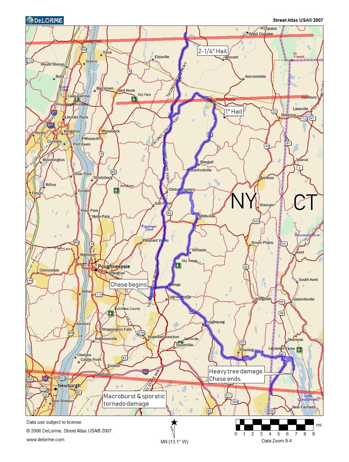
May 22nd, 2018---: Took an extended break from this blog, so hence why there were no "2017" updates. But, the events of May 15th of this year I felt were worthy of an update, so here it goes! A rare combination of ingredients came together over the Lower Hudson Valley of New York State on May 15th, and since Dave and I were still here in the area, as Tornado Alley has been quiet so far this season, we decided to give it a go and chase. The thing that jumped out at us the most were the very steep mid-level lapse rates for this part of the country. Lapse rates approaching 8.5C isn't something that happens around here all too often. That along with the combination of good speed/directional shear prompted a rare Moderate Risk 10% Tornado from the Storm Prediction Center. I headed up to meet Dave at his house near Poughkeepsie, NY and by the time we met up, storms were already getting their act together north of us by about 30 miles. And these weren't your usual multi-cellular storms that are most common here in the northeast, these were legit supercell thunderstorms. We decided to pull off the Taconic State Parkway at the Gallitin Overlook about 20 miles east of Saugerties, NY and await the storm to our west. Visibilty is very limited in NY State, so when we found a scenic overlook in the path of the storm, we felt that was our best option. It wasn't long before the lightning began to pick up, and a visible wall cloud came into view just to our west. We both felt that hail was a good likelyhood, but had no idea how big it would ultimately get. We quickly found out. Once the hail began, it quickly grew in size from quarters, to over golf balls, with some tennis balls in there as well! People began pulling off the Taconic left and right, and many had already lost glass. Several vehicles had shattered windshields and rear windows, and all of them experienced some considerable body damage. Thankfully Dave and I had already installed the hail guards in anticipation for our yearly trip to Tornado Alley, so I did not lose any glass. But, I did receive the first hail dents on my 2013 Xterra! Who knew that the first significant hail damage to my vehicle would be gotten in my home state of NY. Definitely didn't see that coming.
Below is a map showing our route that day starting from Dave's in Poughkeepsie. And below that is the detailed National Weather Service assessments of the days events. Several tornadoes did touch down, but none became visible to us due to the rain wrapped nature of them. After the hail passed, we tracked the storms into northwest Connecticut where we documented extensive tree and power line damage. Definitely a rare day for NY State, but I've noticed that during very quiet years out on the Plains, the northeast has a tendency to be active. We'll see if that trend continues over the coming weeks and months.
Video of the hail storm we experienced is now up on my "Storm Chasing Videos" page
Public Information Statement...UPDATED National Weather Service New York NY 1003 PM EDT Thu May 17 2018
...NWS DAMAGE SURVEY FOR 05/15/2018 TORNADO AND MACROBURST/MICROBURST EVENTS...
...EF0 TORNADO CONFIRMED IN NEWBURGH NY...
Start Location...Newburgh in Orange County NY
End Location...Newburgh in Orange County NY
Date...May 15 2018
Estimated Time...416 PM EDT
Maximum EF-Scale Rating...EF0
Estimated Maximum Wind Speed...75 mph
Maximum Path Width...50 yards
Path Length...0.62 miles
Beginning Lat/Lon...41.5359/-74.0120
Ending Lat/Lon...41.5361/-74.0001
...SUMMARY...
Based on a National Weather Service damage survey done in
conjunction with the Newburgh Fire Department, it has been
determined that an EF0 tornado went through the Balmville
neighborhood of Newburgh. The tornado originated near Albany Post
Road, to the south of the intersection with Bennet Road. The
tornado lifted near the Hudson River behind the house at 56 Susan
Drive. The tornado sheared off trees around half way to the
ground, pealed the bark off of one tree, and caused localized
convergence of uprooted trees. It also caused leaves to be
plastered on three sides of houses in the Susan Drive area. Based
on this, the tornado was classified as an EF0 tornado with an
estimated maximum wind speed of around 75 mph.
The tornado was embedded in a much larger area of straight line
winds, which impacted the northern portion of the town of
Newburgh. These winds sheared off and uprooted trees, all lying in
one direction. Wind speeds for these straight line winds were
estimated at 80 to 90 mph.
...EF2 TORNADO CONFIRMED IN KENT NY...
Start Location...Kent in Putnam County NY
End Location...Kent in Putnam County NY
Date...May 15 2018
Estimated Time...429 PM EDT to 430 PM EDT
Maximum EF-Scale Rating...EF2
Estimated Maximum Wind Speed...115 mph
Maximum Path Width...100 yards
Path Length...1.14 miles
Beginning Lat/Lon...41.5010/-73.6845
Ending Lat/Lon...41.4878/-73.6713
...SUMMARY...
Based on a National Weather Service storm survey, done in
conjunction with the Putnam County Bureau of Emergency
Services, is been determined that an EF2 tornado with estimated
peak winds of 115 mph moved through Kent, New York. The tornado
originated near apartments at 1213 New York Route 52. It continued
down NY State Route 52, damaging some roofs in the strip mall at
the intersection of Route 52 and Farmers Mill Road, where it also
knocked down portions of the parapet above the Dunkin Donuts, and
snapped and uprooted some trees. The tornado lifted near 72 Bowen
Road in Kent. The most extensive damage was along Schuykill
Court, where dozens of large trees were uprooted and snapped, with
a convergent pattern to most of the fallen trees. Based on this
damage, the tornado was classified as an EF2, with estimated
maximum winds of around 115 mph.
...MACROBURST CONFIRMED IN KENT NY...
Location...Kent in Putnam County NY
Date...May 15 2018
Estimated Time...429 PM EDT
Estimated Maximum Wind Speed...80-90 mph
Maximum Path Width...3 miles
Path Length...4 miles
...SUMMARY...
Based on a National Weather Service storm survey, done in
conjunction with the Putnam County Bureau of Emergency Services,
it has been determined that a macroburst with maximum wind speeds
of 80-90 mph impacted a swath of about three miles in width and
four miles in length in the Terry Hill area around 429 PM EDT.
...EF1 TORNADO CONFIRMED IN PATTERSON NY...
Start Location...Patterson in Putnam County NY
End Location...Patterson in Putnam County NY
Date...May 15 2018
Estimated Time...432 to 434 PM EDT
Maximum EF-Scale Rating...EF1
Estimated Maximum Wind Speed...100 mph
Maximum Path Width...75 yards
Path Length...2.89 miles
Beginning Lat/Lon...41.4949/-73.5801
Ending Lat/Lon...41.4585/-73.5526
...SUMMARY...
Based on a National Weather Service storm survey, done in
conjunction with the Putnam County Bureau of Emergency Services,
is been determined that an EF1 tornado with estimated peak winds
of 100 mph moved along a discontinuous path through Patterson, New
York. The tornado originated along NY State Route 22, north of
the intersection with Haviland Hollow Road, near the Watchtower
Educational Center. The tornado then tracked along East Branch
Road, turned left toward Putnam Lake, then lifted near the
intersection of East Branch Road and Fairfield Drive. The storm
snapped multiple trees along its path, not all of it continuous.
The most extensive damage occurred in the general vicinity of 706
East Branch Road, where multiple trees were uprooted and snapped,
lying in a convergent pattern, and where leaves were splattered on
three sides of the house. Based on this information, the tornado
was classified as an EF1 with estimated maximum winds of 100 mph.
...MACROBURST CONFIRMED FROM NEW FAIRFIELD CT TO BROOKFIELD CT...
Start Location...New Fairfield in Fairfield County CT
End Location...Brookfield in Fairfield County CT
Date...May 15 2018
Estimated Time...437 PM EDT to 453 PM EDT
Estimated Maximum Wind Speed...110 mph
Maximum Path Width...3 miles
Path Length...9 miles
Beginning Lat/Lon...41.4651/-73.5347
Ending Lat/Lon...41.4782/-73.3509
* Fatalities...2
* Injuries...1
...SUMMARY...
Based on a National Weather Service storm survey, done in
conjunction with the Connecticut State Police and the Town of
Brookfield, it has been determined that a macroburst with maximum
wind speeds of 110 mph impacted a swath about 3 miles in width and
9 miles in length from New Fairfield through Brookfield from
about 437 PM EDT to 453 PM EDT. Numerous hardwood and pine trees
were uprooted and snapped, with the most significant surveyed
damage in Brookfield from the Candlewood Shores area, extending
east across Route 7, to just north of the Senior High School, to
Lake Lillinonah. Falling trees caused two fatalities, one
in New Fairfield and another in Brookfield, and one serious injury
via wind damage to the roof of a baseball dugout.
Macrobursts can cause as much damage as if not more than
tornadoes due to their size and scope.
...MICROBURST CONFIRMED IN NORTH SALEM NY...
Location...North Salem in Westchester County NY
Date...May 15 2018
Estimated Time...441 PM EDT
Estimated Maximum Wind Speed...80 mph
Maximum Path Width...50 yards
Path Length...0.5 miles
Beginning Lat/Lon...41.3408/-73.6565
Ending Lat/Lon...41.3340/-73.6542
...SUMMARY...
Based on a National Weather Service storm survey, it has been
determined that a microburst with estimated winds gusting to 80
mph occurred, resulting in approximately a half mile of downed
trees. The damage began near the North Salem Firehouse along NY
Route 22 and ended farther south, running in between the railroad
tracks and the west side of Route 22.
...EF1 TORNADO CONFIRMED FROM SOUTHBURY CT TO OXFORD CT...
Start Location...Southbury in New Haven County CT
End Location...Oxford in New Haven County CT
Date...May 15 2018
Estimated Time...453 PM EDT to 501 PM EDT
Maximum EF-Scale Rating...EF1
Estimated Maximum Wind Speed...100 mph
Maximum Path Width...400 yards
Path Length...4.2 miles
Beginning Lat/Lon...41.4662/-73.1689
Ending Lat/Lon...41.4212/-73.1403
...SUMMARY...
A tornado touched down near the intersection of Route 67 and
Burma Road in Southbury and continued southeast into Oxford,
leaving a path of numerous uprooted and snapped pine trees and
some hardwood trees. The tornado lifted after damaging the roof of
the Great Oak School in Oxford. Based on this information, this
tornado is classified as an EF1 with maximum winds of 100 mph.
...EF1 TORNADO CONFIRMED FROM BEACON FALLS CT TO HAMDEN CT...
Start Location...Beacon Falls in New Haven County NY
End Location...Hamden in New Haven County NY
Date...May 15 2018
Estimated Time...501 PM EDT to 509 PM EDT
Maximum EF-Scale Rating...EF1
Estimated Maximum Wind Speed...110 mph
Maximum Path Width...600 yards
Path Length...9.5 miles
Beginning Lat/Lon...41.4385/-73.0466
Ending Lat/Lon...41.4268/-72.9150
...SUMMARY...
A tornado touched down near the intersection of Bethany Road and
Bonna Street in Beacon Falls, destroyed a barn in Bethany, and
continued on to just west of Sleeping Giant State Park in Hamden,
where the damage path broadened and became more straight-line in
nature. The tornado left a path of numerous uprooted and snapped
hardwood and pine trees. Based on this information, this tornado
is classified as an EF1 with maximum winds of 110 mph.
...MICROBURST CONFIRMED FROM HAMDEN CT TO WALLINGFORD CT...
Start Location...Hamden in New Haven County CT
End Location...Wallingford in New Haven County CT
Date...May 15 2018
Estimated Time...501 PM EDT to 514 PM EDT
Estimated Maximum Wind Speed...100 mph
Maximum Path Width...880 yards
Path Length...7.25 miles
Beginning Lat/Lon...41.4268/-72.9150
Ending Lat/Lon...41.4196/-72.7723
...SUMMARY...
Based on a National Weather Service storm survey, it has been
determined that the earlier Beacon Falls-Hamden tornado transitioned
to a microburst with maximum wind speeds of 100 mph, and impacted a
swath about 1/2 mile in width and 7.25 miles in length, from near
Sleeping Giant State Park and Quinnipiac University, across Wharton
Brook State Park, to just east of Tyler Mill in Wallingford.
Extensive damage occurred, with numerous pine trees uprooted and
snapped.